Electromagnetic studies of the Slave craton: preliminary results and ongoing experiments
Alan G. Jones1, Ian Ferguson2, Gary McNeice3, Rob Evans4 and Alan Chave4
1: Geological Survey of Canada, 615 Booth St., Ottawa, Ontario, K1A 0E9, Canada
2: Department of Geological Sciences, University of Manitoba, Winnipeg, Manitoba, R3T 2N2, Canada
3: Phoenix Geophysics Ltd., 3781 Victoria Park Ave., Unit #3, Scarborough, Ontario, M1W 3K5, Canada
4: Woods Hole Oceanographic Institution, 360 Woods Hole Woods Hole
Introduction
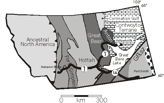
Lithoprobe's SNORCLE (Slave-NORthern Cordilleran Lithospheric Evolution) transect comprises three corridors beginning east of Yellowknife on the Slave craton, host to the oldest dated rocks in the world today (Bleeker et al. 1999), and traversing west to some of the youngest rocks in Canada on British Columbia's west coast. The ACCRETE program (Hollister and Andronicos 1997) extends this transect offshore to cross the active Queen Charlotte transform fault. Thus, the SNORCLE-ACCRETE studies capture all EarthÆs geological history along their combined length, and almost all tectonic settings, either in modern or ancient forms. The Archaean and Proterozoic components of the SNORCLE transect are crossed by profiles 1 and 1A of Corridor 1, and are shown in Fig. 1 on the terrane map of the region (Slave terranes based on Kusky 1990).
Critical to understanding the history, nature and relationships of the exposed or shallow subsurface crustal elements crossed by Corridor 1 is knowledge and understanding of lithospheric-scale processes, from lithospheric formation and deformation to destruction. Of particular interest within the Slave craton segment of SNORCLE transect activities is the debate concerning lithospheric formation and alleged differences between tectonic processes active during Archaean times compared to those during later Proterozoic and Phanerozoic times. Lithospheric growth models of Jordan (1988) and Ashwal and Burke (1989) advance modern-day processes as explanations of tectonic events that occurred during the entire history of the Earth. Conversely, Helmstaedt and Schulze (1989), with modifications by Kusky (1993), suggest more buoyant subduction occurred during Archaean times, leading to continental roots being formed by imbrication of shallowly-subducted lithospheric slabs. Alternative models are proposed by Thompson et al. (1995) and Polet and Anderson (1995) who appeal to non-tectonic processes, basal accretion of cooling mobile asthenospheric material and cold downwelling of lithosphere into the asthenosphere respectively, to explain lithospheric growth. Hoffman (1990) discussed aspects and implications of some of these models for the root of the Canadian Shield part of the North American craton, and concluded that the existing data are not adequate for discriminating between the various models.
High-quality, deep-probing electromagnetic (EM) studies are capable of addressing several questions regarding models of lithospheric formation, and thereby contributing to this debate. In particular, the natural-source magnetotelluric (MT) method is well-suited for probing the upper mantle, compared to controlled-source EM methods. This is due to its simpler logistics, sophisticated data analysis procedures, tensor information, and more tractable mathematics for forward modelling leading to effective two-dimensional (2D), and recently three-dimensional (3D), inversion codes. Jones (1999) demonstrates the contributions that MT studies have made and can make in imaging physical properties and geometrical relationships of the continental lithosphere, and lists the following hypotheses and tests:
Hypothesis 1: The cratonic lithosphere is Archaean in age and has been strongly coupled to its crust since that time.
Test 1: Electrical anisotropy, if present, must extend smoothly through the cratonic root and be approximately aligned with surface structures. A more exacting test would require that the obliquity between the seismic and EM anisotropy directions must define the same sense of movement as surface structures (Ji et al. 1996, hypothesis).
Hypothesis 2: The cratonic lithosphere is comprised of imbricate stacks formed in the Archaean (Helmstaedt and Schulze, 1989, model, with Kusky, 1993, modification).
Test 2: There will be a regional variation in electrical anisotropy direction and possibly in electrical parameters like conductivity or root thickness.
Hypothesis 3: The lithosphere has been added to the craton since the end of the Archaean by basal accretion (Thompson et al., 1996, model).
Test 3: There will be no anisotropy and no regional variation in electrical parameters. If either consistent anisotropy or regional variation is observed, then the hypothesis can be rejected.
Hypothesis 4: The old mantle root is of limited spatial extent and its apparent seismically-determined size is caused by transient cold downwelling (Polet and Anderson, 1995, model).
Test 4: There will be no consistent anisotropy direction, no deep anisotropy, and probably a weak electrical signature over most of the craton. The presence of deep anisotropy and an extensive low conductivity root is cause to reject this hypothesis.
One geometrical parameter that is well resolved by appropriate high quality MT studies is the thickness of the thermal lithosphere, the depth to the thermal lithosphere-asthenosphere boundary generally assumed to be around 1300 OC. This is due to the high sensitivity of electrical conductivity to the onset of ionic conductivity in an interconnected partial melt phase. Laboratory studies on H2O ice - KCl aqueous solution, as an analogue for partially molten Earth materials, demonstrate that electrical conductivity rises very rapidly by many (>2) orders of magnitude at the onset of interconnected partial melt (Watanabe and Kurita 1993). Laboratory studies on mantle materials have generally concentrated on olivine, particularly peridotite.
Deep-probing EM studies of the Slave craton are occurring at a time when there is much interest in obtaining knowledge about the deep lithosphere to aid exploration activities for CanadaÆs fledgling diamond-industry (Jones et al. 1996). Current models for diamondiferous kimberlite emplacement require a thick (>150 km), cold lithosphere, whereas thinner lithosphere will result in barren kimberlites (Mitchell 1991). Given the presently-known distribution of diamondiferous kimberlites across the Slave, imaging the geometry of the base of the lithosphere, and its spatial variation, may lead to further understanding of mantle processes, such as focusing of upwelling material.
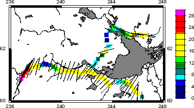
This paper summarises the EM experiments that have been, and are being, conducted on the Slave craton and adjacent Proterozoic terranes to the west. Four different types of experiments have been, or are, underway, and the site locations on the Slave are shown on Fig. 2, together with the locations of the teleseismic sites of Bostock and Cassidy (1997). The EM studies began in 1996, and will continue until the year 2000, and perhaps beyond if problems and interest remain.
Objectives of the SNORCLE EM program on the Slave craton
The general objective of the SNORCLE program are given in the Lithoprobe Phase V proposal (Clowes 1997). Many of these objectives are pertinent to the Slave craton and adjacent Proterozoic terranes, and can be directly addressed using electromagnetic methods. We have classified these objectives into three groups, which are discussed below.
Characterising the deep crust and mantle between the oldest rocks to the younger Proterozoic terranes
This component will permit addressing the following stated transect objectives:
This is being accomplished by the acquisition of contracted wide-band MT sites together with long period MT sites installed at the same locations, and using the same electrode array. The wide-band data measure frequencies in the range 0.01 û 1,000 Hz (or periods of 0.001 û 100 s), and give information primarily about the crust. The long period data measure periods in the range 10 û 10,000 s, and can give information about the mantle to depths in excess of 200 km. The MT site locations are nominally equi-spaced, with a station spacing of around 15 km, but the surveys are run in "dynamic" mode with in-field processing and modelling permitting identification of critical repeat and infill site locations.
In addition, in order to address the Slave mantle root geometry characterisation, two other experiments are underway and are discussed in detail below. The first involves making measurements along the 600-km-long winter road to the north-east of Yellowknife, and is in partnership with industry. The second is a joint U.S.-Canadian project that entails installing shallow-water ocean-bottom MT equipment in lakes across the Slave craton. Both of these are the first of their kind.
Characterising the geometry of the major vertical structures
Knowing the current geometry of vertical structures permits one to address such transect objectives as:
EM studies have shown their superior effectiveness in determining the geometry of vertical structures to whole crustal depths over other geophysical methods (e.g., Fraser Fault, Jones et al. 1992; San Andreas fault, Unsworth et al., 1977). Following regional-scale data acquisition, closely-spaced (1 km) MT stations in the vicinity of each of the three major vertical structures, the Great Slave Lake Shear Zone, the Tintina-Rocky Mountain Trench Fault and the Denali Fault, are planned. Spatially-continuous electric field recording across the faults, using continuous electric-field dipoles, would yield the best image possible, and an excellent example is shown by the work across the San Andreas fault (Unsworth et al., 1977), but such surveys are not currently planned.
Auxiliary objectives
In addition to the stated SNORCLE objectives, there are additional objectives that can be addressed by EM studies on the Slave craton and adjacent terranes, and an objective related to processing of MT data from magnetically high latitudes:
The enigmatic long-period electrical anisotropy results of the Superior craton presented by Mareschal et al. (1995) require formation or deformation processes that result in mantle lithospheres with preferentially-aligned conducting fabrics. This observation parallels the seismically-observed time delays between arriving shear waves in orthogonal directions and interpreted as mantle anisotropy (Silver and Chan 1988, 1991). The small, but statistically-meaningful, obliquity between the direction of maximum conductivity and the shear-wave splitting fast directions (Senechal et al. 1996) were interpreted by Ji et al. (1997) as evidence for strong crustal-mantle coupling since lithospheric formation and as a potential indicator of the movement sense for ductile mantle shear zones. This thesis needs to be tested by making collocated MT and teleseismic observations at other locations and on other Archaean cratons.
Padgham and Fyson (1992) presented geological arguments that the Slave craton is geologically distinct compared to other Archaean cratons. How the electrical properties of the Slave cratonic mantle compare to others, particularly the Superior craton, addresses the question of the uniqueness of the Slave craton geophysically.
A very long period, high-quality, deep-probing experiment on the Superior craton demonstrated that the electrical conductivity of the mantle has discrete jumps at approximately 410 km and 660 km (Schultz et al. 1993). The former is consistent with recent laboratory work that shows a two orders of magnitude increase in conductivity as olivine undergoes a phase transformation to higher pressure mineralogy (wadsleyite) (Xu et al. 1998). This phase transformation is a pressure-effect, and accordingly should be seen at all localities. However, with the exception of the data of Schultz et al. (1993), the existing database of mantle MT response functions is insufficiently precise to be able to verify this laboratory inference. A step-like increase in conductivity is consistent with the EM responses observed in western United States of America, but not required by them (Egbert and Booker 1992). High quality very long period MT response functions need to be obtained for the Slave craton to compare with the results from the Superior craton, and with other cratons worldwide.
Finally, there is a lot of interest in making deep-probing MT measurements at high geomagnetic latitudes, both in Canada and elsewhere, to determine information about the lithosphere. The non-uniform field of the aurora borealis can have a severe effect on MT response function estimation, and an example is shown in Garcia et al. (1997). An experiment has been performed to acquire almost a year of data under the auroral zone for analysis and development of appropriate processing methods (see below).
Electromagnetic experiments to date
Snorcle Corridor 1 acquisition
The first phase of acquisition of EM data along the SNORCLE transect began on August 1st, 1996, with a sixty (60) station contracted magnetotelluric (MT) survey along SNORCLE Corridor 1 (Figs. 1 and 2), including the Fort Providence - Wood Buffalo National Park profile (profile 1A, Fig. 1). The contractor (Phoenix Geophysics Ltd.) acquired the wide-band MT data pertinent primarily to the crust. In addition, longer period measurements were made at each location to image conductivity features in the sub-crustal lithosphere down to the conducting asthenosphere.
Thirteen sites were located on the exposed Slave craton, from Tibbit Lake to Rae, nine on the Great Bear magmatic arc, from Rae to Fort Providence, twenty-four on the Proterozoic section (Hottah, Fort Simpson and Nahanni terranes), from Fort Simpson to Nahanni Butte, and fifteen on the section crossing the Great Slave Lake shear zone, from Fort Simpson to within the boundaries of Wood Buffalo National Park. High frequency data (10 kHz to 0.01 Hz) were acquired by the commercial contractor with three nights of recording at all sites. There was one to four weeks recording of long period MT data (20 - 30,000 s), using fifteen GSC-built LiMS (Long period Magnetotelluric System) units, at each location by the scientist plus an assistant monitoring the contracted data acquisition.
The wide-band MT data (using Phoenix's V5 system) were processed in the field using a robust remote-reference code based on the algorithm of Jones and Jödicke (1984; method 6 in Jones et al. 1989). The LiMS data have only undergone preliminary processing, as final processing will include using data from the Yellowknife geomagnetic observatory and three sites operated as part of the CanadaÆs Space Agency MARIA array (Contwoyto Lake, Fort Simpson and Fort Smith) as remote reference fields to remove noise effects and also reduce non-uniform source field contamination. Subsequent to data acquisition, a problem was identified trying to merge together the V5 and LiMS responses. After exhaustive and lengthy enquiry, it was discovered that there was an imprecision in the coil calibration procedures used by the contractor for extrapolating the coil response beyond the measured calibration range. The effects of this problem were such that the original V5 data at periods greater than 8 s were in error by up to 10O in phase, and the equivalent value in apparent resistivity. This is far too large to be acceptable, and the V5 time series were all reprocessed using corrected calibration factors. The corrected data were delivered to the GSC/Lithoprobe in December, 1998.
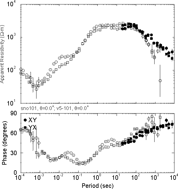
Figure 3 illustrates an example of the corrected V5 data together with the LiMS data from a site just to the west of Rae on the Great Bear magmatic arc (site 101). Even at this level of processing of the LiMS data, the overall data quality from both is excellent. Reasonable V5 data were even acquired in the high frequency "dead-band" of 1 kHz - 3 kHz, albeit with lower quality. There is a drop-off of the V5 data at the longest periods due to the inferior sensitivity at long periods of the coil magnetometer used for the V5 system compared to the ring-core fluxgate magnetometer used for the LiMS system (the opposite is true at high frequencies, >0.1 Hz). The absence of anthropogenic noise and low electric field distortion compound to give highly precise estimates of the magnetotelluric impedance tensor in all elements for almost all sites, which is rarely the case for MT data acquired on highly resistive regions (cratons, batholiths, etc.).
Winter Road acquisition
Vehicle access of the Slave craton is limited, and Echo Bay's 600-km-long winter road, from Tibbit Lake east of Yellowknife to the Lupin gold mine at Contwoyto Lake (Fig. 2), provides a logistical opportunity to extend the geophysical observations from around the south-west corner of the Slave craton to well into the interior. In particular, the winter road affords the possibility to cross the boundary between the Central Slave Basement Complex and the presumed juvenile eastern Slave (Bleeker et al. 1999), and to map electrically the lateral variation of the crust and sub-crustal lithosphere across the Slave craton. Secondary roads off the main winter road afford access to regions further to the east and west.
MT acquisition along the winter road is a relatively-affordable geophysical method for obtaining information on the regional-scale, lateral variation of the Slave lithosphere, and will contribute significantly to the objectives of the SNORCLE transect. The winter road has a total length of ca. 600 km, requiring a minimum of 40 MT sites to characterise the deep structure electrically. The results should provide an improved picture of the assembly of the Slave Province and allow evaluation of lithospheric growth models such as that of Helmstaedt and Schulze (1989) and Kusky (1989).
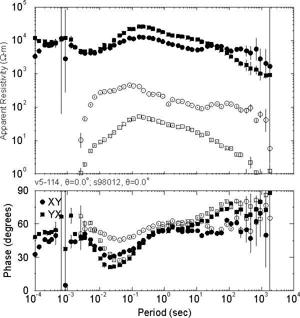
In April, 1997, a feasibility study was undertaken in northern Ontario of the logistical and scientific challenges faced by attempting to make measurements on a frozen lake surface. The tests undertaken demonstrated that it is important to make the telluric measurements with the electrodes in contact with the sediments at the lake bottom, whereas the magnetic field measurements need to be made on the lake shore due to the noise induced by ice movement (McNeice and Jones 1998). Subsequently, a pilot study along the winter road took place during March-April, 1998, of twelve sites. Three of these were at the southern terminus of the winter road close to Tibbet Lake, and the other nine were in an east-west profile from the northern end of Gordon Lake to the western end of MacKay Lake. A comparison of the data from this survey to the data from the 1996 land-based survey is shown in Fig. 4. There is a shift in the apparent resistivity curves due to local electric field distortion effects caused by the lake geometry. Such distortions are well-understood, and methods exist for identifying and removing the phase effects of these distortions (e.g., Groom et al. 1993). The amplitude effects, known as "static shifts" (Jones 1988; Sternberg et al. 1988), are more difficult to remove, but methods exist and are being developed further.
Slave Lakes experiment
Although the winter road work will give access to the interior of the Slave craton, it does run the danger of being in part along a possible mantle boundary, as inferred by the Pb and Nd isotope boundaries (Thorpe et al. 1992; Davis et al. 1996). In order to obtain broader regional coverage of the craton at as minimal a cost as possible, a novel experiment is in progress involving deploying shallow-water EM instrumentation designed to operate on the ocean bottom of the continental shelves in lakes on the craton. This type of instrumentation had only been deployed once before, as part of the SoAp (Southern Appalachians) experiment (Ogawa et al. 1996; Wannamaker et al. 1996), on the continental shelf off the coast of the Carolinas. The SoAp experiment was an onshore-offshore EM study of the Atlantic passive margin on a scale almost as large as the EMSLAB experiment of the active Pacific margin (Booker and Chave 1989; Wannamaker et al., 1989a, 1989b).
Using a float plane, the total compliment of ten instruments were deployed in lakes around the Slave craton during early July, 1998. The locations of the lake sites are shown in Fig. 2, and comprise roughly three east-west lines. The northern line comprises three lakes (Point Lake, Contwoyto Lake and Rockinghorse Lake), the central line four lakes (Indin Lake, Snare Lake, Big Lake and Lac de Gras), and the southern line also four lakes (Wheeler Lake, Duncan Lake and Lac Tet d'Ours). The systems have been set with a recording rate of one sample per second for the first two months (July and August, 1998), followed by a rate of one sample per minute for the remaining ten months. In July these instruments will be retrieved, and hopefully re-deployed in August, 1999 in another ten lakes.
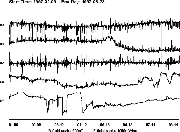
Yellowknife Observatory long-term recording experiment
A single LiMS instrument was deployed close to the Yellowknife Geophysical Observatory for a year, from August 8th 1997 to August 28th 1998. Initial malfunctions were repaired, and continuous data exist from January 9th until August 28th 1998. The complete time series are shown in Fig. 5. For this installation, the analogue high-pass telluric filters, with their nominal û3 dB period set for 30,000 s, were bypassed in an attempt to obtain response function estimates to a day or longer. Such periods probe the deep mantle, and would allow for a comparison with the very long period measurements made on the Superior craton by Schultz et al. (1993).
Preliminary results
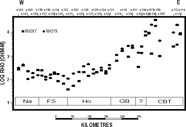
The lateral variation of electrical properties of the subcrustal lithosphere can be derived from the lateral variation in the MT parameters. Figure 6 shows the apparent resistivities at a period that is sampling about 50 km into the lithosphere (30 s) for the MT sites along profile 1 (Fig. 1). The values rise from 100-300 W .m on the Proterozoic terranes to around 10,000 W .m on the Slave craton. This rise occurs mostly on the Fort Providence to Rae section of the profile across the Great Bear magmatic zone. These results imply that the lithosphere thins dramatically westward beneath the Great Bear magmatic zone. Preliminary modelling suggests that the lithosphere-asthenosphere boundary is 100+ km west of Fort providence, and around 200+ km beneath the Rae-Yellowknife section. To the east of Yellowknife the lithosphere may thin again, but only by a small amount.
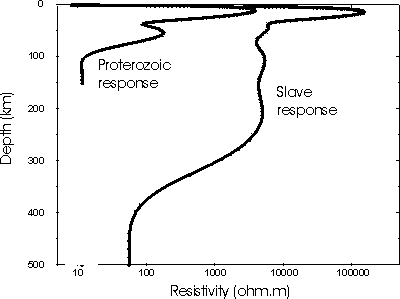
One-dimensional inversions of the averaged V5 MT data from two representative sites, one on the Proterozoic terranes (site 135, on the Fort Simpson terrane) and one on the Slave craton (site 106, on the western edge of the Central Slave Basement Complex), are shown in Fig. 7. At both sites there is high resistivity in the crust that drops at about the crust-mantle boundary. The resistivity of the mantle beneath the two regions is very different. There is a decrease to low values around 100 km beneath the Proterozoic terranes, whereas beneath the representative Slave craton site this decrease does not occur until depths of some hundreds of kilometres. Modelling this observation in the MT response as a step-like decrease would put the change at 350 km +/- 150 km. This boundary will be better resolved when the LiMS data are processed and merged with the V5 data.
With the phase difference between orthogonal impedances of the MT tensor it is possible to determine whether there is any anisotropy in the measurements associated with structures, similar to the SKS technique in seismology. Figure 8 displays the phase differences for all stations at the same period as Fig. 6. Beneath stations from Yellowknife and further east, the lithosphere is electrically anisotropic, with the more conductive direction being around 105O, compared to the seismic SKS direction for the Yellowknife observatory of 048O. The lithosphere is laterally homogeneous between Fort Providence and Rae, but becomes anisotropic west of Fort Providence (Fig. 8). Sites around the Great Slave Lake shear zone display a strong anisotropy with a most conductive direction of 035O, i.e., oblique to the direction of the GSLsz of 045O. This anisotropy at such long periods suggests that the GSLsz penetrates deep into the mantle. The obliquity between the maximum conducting direction and the surface trace of the GSLsz is consistent with the dextral movement sense on the shear zone, following the hypothesis of Ji et al. (1996).
Further Work
The second phase of winter road acquisition will take place during Feb 22nd to early April, 1999. Phoenix Geophysics is being contracted for 30 acquisition days, and the expectation is that there will be a minimum of 25 MT soundings made during that time. The sites will be mainly along the northern section of the road from MacKay lake to the Lupin Mine on Contwoyto Lake. In addition, there will be two fill-in sites at the southern end of the line, plus sites along minor roads to the east and west. One in particular of interest is the road to Kennedy Lake, which is a property owned by Monopros.
A number of companies have offered logistical support for this survey. Giant Mine will allow the crew to stay in their field house whilst in Yellowknife. Diavik have offered board and lodging at their camp on Lac de Gras. BHP, Winspear and Monopros have offered the same at their camps at Ekati, Snap Lake and Kennady Lake respectively. Additional financial savings over the previous survey will be made by using government-owned snowmobiles, sleds, ice augers and batteries.
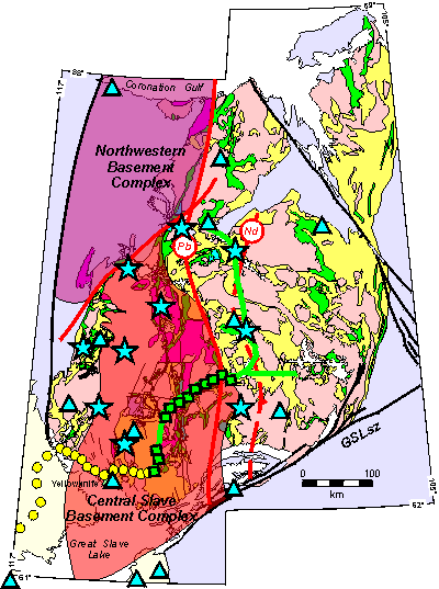
The Slave Lakes experiment was funded jointly by Lithoprobe and National Science Foundation's Continental Dynamics for one deployment. Lithoprobe committed to providing the field costs for the experiment, and allocated $25,000 for this. Total field costs for the installation were slightly under $15,000. The lakes into which the instruments are installed are shown in Fig. 2 on the new geological interpretation of the basement terranes from Wouter Bleeker. Unfortunately, as is apparent in the figure, we have no stations on the Northwestern Basement Complex, and little coverage into the eastern domain of the Slave.
We wish to rectify this situation by having a second deployment into ten other lakes. The locations of those ten are open for debate, but we propose that there should be two profiles with reasonable coverage crossing the isotope boundaries, one in the south and one in the north. A deployment configuration that would satisfy this is to have four instruments infill the current central line; two between Snare Lake and Lac de Gras, and two to the east of Lac de Gras, and a new profile of five sites at about the latitude of the Ulu mine (shown by the location of the teleseismic site). The tenth instrument would be reserved as a spare, and perhaps installed into the region west of the Central Slave Basement Complex.
A second deployment will in addition give us the opportunity to modify the instruments after they have been recovered. These instruments have never before been used in this way before, and that no experiment equivalent to this has ever taken place.
Also, the proposed northern line will give us an image of the lithosphere beneath the northern Slave craton which is thought to have been highly modified as a consequence of the mantle plume that gave rise to the MacKenzie dyke swarm (1267 Ma).
Information will be continually updated at the SNORCLE EM web page http://www.geophysics.dias.ie/~ajones/snorcle/snorcle.html.
Acknowledgements
The Winter road work is partially funded by Kennecott, Monopros, DIAND and B.H.P. Logistical support is provided by Royal Oak, Diavik, Winspear and Monopros.
The Slave Lakes project was funded by a National Science Foundation Continental Dynamics Program grant to Woods Hole Oceanographic Institution. Thanks to staff of Air Tindi for their design and construction of the winch.
Staff of the Yellowknife Geophysical Observatory, Bill Outhwaite and George Jensen, and former staff member Andy Langlois, provided much logistical support for all experiments.
References
Ashwal, L.D., and K. Burke, 1989. African lithospheric structure, volcanism, and topography, Earth and Planetary Science Letters, 96, 8-14.
Bleeker, W., J.W.F. Ketchum, V.A. Jackson and M. Villeneuve, 1999. The Central Slave Basement Complex, Part I: Its structural topology and autochthonous cover. Can J. Earth Sci., in press.
Booker, J.R. and Chave, A.D., 1989. Introduction to the Special Section on the EMSLAB-Juan de Fuca Experiment. J. Geophys. Res., 94: 14,093-14,098.
Bostock, M.G. and Cassidy, J.F., 1997. Upper mantle stratigraphy beneath the southern Slave Craton. Can. J. Earth Sci., 34, 577-587.
Clowes, R.M. (Editor), 1997. Lithoprobe Phase V Proposal - Evolution of a Continent Revealed. Publ. By Lithoprobe Secretariate, The University of British Columbia, Vancouver, B.C., pp. 292.
Davis, W.J., Gariepy, C. and Van-Breemen, O., 1996. Pb isotopic composition of late Archaean granites and the extent of recycling early Archaean crust in the Slave Province, northwest Canada. Chemical Geology, 130, 255-269.
Egbert, G.D. and Booker, J.R., 1992. Very long period magnetotellurics at Tucson Observatory: Implications for mantle conductivity. J. Geophys. Res., 97, 15,099-15,112.
Garcia, X., Chave, A.D. and Jones, A.G., 1997. Robust processing of magnetotelluric data from the auroral zone. J. Geomagn. Geoelectr., 49, 1451-1468.
Groom, R.W., Kurtz, R.D., Jones, A.G. and Boerner, D.E., 1993. A quantitative methodology for determining the dimensionality of conductive structure from magnetotelluric data. Geophys. J. Internat., 115: 1095-1118.
Helmstaedt, H.H., and D.J. Schulze, Southern African kimberlites and their mantle sample: implications for Archean tectonics and lithosphere evolution, in J. Ross (ed.), Kimberlites and related rocks, vol. 1: Their composition, occurrence, origin, and emplacement, Geol. Soc. Aust. Spec. Pub., 14, 358-368, 1989.
Hoffman, P.F., 1990. Geological constraints on the origin of the mantle root beneath the Canadian shield. Phil. Trans. R. Soc. London, A331, 523-532.
Hollister, L.S., and Andronicos, C.L., 1997, A candidate for the Baja British Columbia fault system in the Coast Plutonic Complex. GSA Today, 7, 1-7.
Ji, S., S. Rondenay, M. Mareschal and G. Senechal, 1996. Obliquity between seismic and electrical anisotropies as a potential indicator of movement sense for ductile mantle shear zones. Geology, 24, 1033-1036.
Jones, A.G., 1988. Static shift of magnetotelluric data and its removal in a sedimentary basin environment. Geophysics, 53: 967-978.
Jones, A.G., 1999. Imaging the continental upper mantle using electromagnetic methods Lithos, accepted.
Jones, A.G., Chave, A.D., Egbert, G., Auld, D., and Bahr, K.1989 A comparison of techniques for magnetotelluric response function estimation. J. Geophys. Res., 94: 14,201-14,213.
Jones, A.G., Eaton, D.W., White, D., Bostock, M., Mareschal, M. and Cassidy, J., 1996. Geophysical measurements for Lithospheric parameters. In: Searching for Diamonds in Canada, A.N. LeCheminant, R.N.W. DiLabio, and K.A. Richardson (ed.), Geological Survey of Canada, Open File 3228, 243-250.
Jones, A.G., Kurtz, R.D., Boerner, D.E., Craven, J.A., McNeice, G., Gough, D.I., DeLaurier, J.M., and Ellis, R.G., 1992. Electromagnetic constraints on strike-slip fault geometry -- the Fraser River fault system. Geology, 20: 561-564.
Jordan, T.H., 1988. Structure and formation of the continental tectosphere, J. Petrol., Special Lithosphere Issue, 11-37.
Kusky, T.M., 1989. Accretion of the Archaean Slave province. Geology, 17, 63-67.
Kusky, T.M., 1990. Evidence for Archean ocean opening and closing in the southern Slave province. Tectonics, 9, 1533-1563.
Kusky, T.M., 1993. Collapse of Archean orogens and the generation of late- to postkinematic granitoids. Geology, 21, 925-928.
LeCheminant, A.N. and Heaman, L.M., 1989. Mackenzie igneous events, Canada: middle Proterozoic hotspot magmatism associated with ocean opening. Earth and Planetary Science Letters, 96, 38-48.
Mareschal, M., Kellett, R.L., Kurtz, R.D., Ludden, J.N. and Bailey, R.C.. 1995. Archean cratonic roots, mantle shear zones and deep electrical anisotropy. Nature, 373: 134-137.
McNeice, G. and A.G. Jones, 1998. Magnetotellurics in the frozen north: measurements on lake ice. Contributed paper at: 14th EM Induction Workshop, Sinaia, Romania, August 16-23.
Mitchell, R.H., 1991. Kimberlites and lamproites: primary sources of diamond. Geoscience Canada, 18, 1-16.
Ogawa, Y., Jones, A.G., Unsworth, M.J., Booker, J.R., Lu, X., Craven, J., Roberts, B., Parmelee, J. and Farquharson, C., 1996. Deep electrical conductivity structures of the Appalachian Orogen in the southeastern U.S. Geophys. Res. Lett., 23: 1597-1600.
Padgham, W.A. and W.K. Fyson, 1992. The Slave Province: a distinct Archaean craton. Can. J. Earth Sci., 29, 2072-2086.
Polet, J., and D.L. Anderson, Depth extent of cratons as inferred from tomographic studies, Geology, 23, 205-208, 1995.
Schultz, A., R.D. Kurtz, A.D. Chave and A.G. Jones, 1993. Conductivity discontinuities in the upper mantle beneath a stable craton. Geophys. Res. Lett., 20, 2941-2944.
Senechal, G., Rondenay, S., Mareschal, M., Guilbert, J. and Poupinet, G., 1996. Seismic and electrical anisotropies in the lithosphere across the Grenville Front, Canada. Geophys. Res. Lett., 23: 2255-2258.
Silver, P.G., and W.W. Chan, Implications for continental structure and evolution from seismic anisotropy, Nature, 335, 34-39, 1988.
Silver, P.G. and Chan, W.W., 1991. Shear-wave splitting and subcontinental mantle deformation. J. Geophys. Res., 96: 16,429-16,454
Sternberg, B.K., Washburne, J.C. and Pellerin, L., 1988. Correction for the static shift in magnetotellurics using transient electromagnetic soundings. Geophysics, 53: 1459-1468.
Thompson, P.H., A.S. Judge, and T.J. Lewis, Thermal evolution of the lithosphere in the central Slave Province: Implications for diamond genesis, in Searching for Diamonds in Canada, A.N. LeCheminant, D.G. Richardson, R.N.W. DiLabio and K.A. Richardson (ed.), Geol. Surv. of Canada, Open File 3228, 151-160, 1996.
Thorpe, R.I., Cumming, G.L. and Mortensen, J.K., 1992. A significant Pb-isotope boundary in the Slave province and its probable relation to ancient basement in the western Slave province. In Project Summaries, Canada-Northwest Territories Mineral Development Subsidiary Agreement 1987-1991. Edited by D.G. Richardson and M. Irving. Geological Survey of Canada Open File 2484, 179-184.
Unsworth, M.J., P.E. Malin, G.D. Egbert and J.R. Booker, 1997. Internal structure of the San Andreas Fault at Parkfield, California. Geology, 25: 359-362.
Wannamaker, P.E., Booker, J.R., Filloux, J.H., Jones, A.G., Jiracek, G.R., Chave, A.D., Waff, H.S., Young, C.T., Stodt, J.A., Martinez, M., Law, L.K., Yukitake, T., Segawa, J.S., White, A. and Green, A.W., 1989a. Magnetotelluric observations across the Juan de Fuca subduction system in the EMSLAB project. J. Geophys. Res., 94: 14,111-14,125.
Wannamaker, P.E., Booker, J.R., Jones, A.G., Chave, A.D., Filloux, J.H., Waff, H.S. and Law, L.K., 1989b. Resistivity cross-section through the Juan de Fuca subduction system and its tectonic implications. J. Geophys. Res., 94: 14,127-14,144.
Wannamaker, P.E., Chave, A.D., Booker, J.R., Jones, A.G., Filloux, J.H., Ogawa, Y., Unsworth, M. and Evans, R., 1996. Sutures and deep physical state of the SE U.S. Atlantic margin: The Southern Appalachians magnetotelluric experiment. EOS. 77, 329-333.
Xu, Y. B.T. Poe, T.J. Shankland and D.C. Rubie, 1998. Electrical conductivity of olivine, wadsleyite and ringwoodite under upper-mantle conditions. Science, 280, 1415-1418.