Results from 1996 MT studies along SNORCLE profiles 1 and 1A
Alan G Jones, Geological Survey of Canada
Ian J Ferguson, University of Manitoba
Nick Grant, Gaia Geophysics
Brian Roberts, Geological Survey of Canada
Colin Farquharson, University of British Columbia
SNORCLE scientific and transect objectives
The first phase of line-item acquisition of EM data along the SNORCLE transect began on August 1st, 1996, with a sixty (60) station magnetotelluric (MT) survey. A contractor (Phoenix Geophysics Ltd.) acquired the high frequency data pertinent to primarily the crust. In addition, longer period measurements were made at each location to image conductivity features in the sub-crustal lithosphere down to the conducting asthenosphere.
Overall and specific "Slave" objectives that can be addressed by these MT studies include:
1996 Field Program
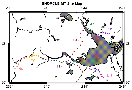
During August-October, 1996, sixty magnetotelluric sites were acquired along the whole of the SNORCLE Corridor 1 transect (Fig. 1), including the Fort Providence - Wood Buffalo National Park profile (Profile 1A). There were 13 sites on the exposed Slave craton from Tibbit Lake to Rae, 9 on the Great Bear magmatic arc from Rae to Fort Providence, 24 on the Proterozoic section (Hottah, Fort Simpson and Nahanni terranes) from Fort Simpson to Nahanni Butte, and 15 on the section crossing the Great Slave Lake shear zone (GSLsz) from Fort Simpson to within the boundaries of Wood Buffalo. At all sites was acquisition of high frequency (10 kHz to 0.01 Hz) data by a commercial contractor (Phoenix Geophysics), with three nights of recording. Additionally, there was one to four weeks recording of long period (20 - 30,000 s) data, using fifteen GSC LIMS (Long period Magnetotelluric System) units, at each location by the bird-dogger and Nick Grant (a contracted field assistant).
The wideband MT data (using Phoenix's V5 system) were processed in the field using a robust remote-reference code based on the algorithm of Jones and Jödicke (1984). The LIMS data have only undergone preliminary processing, as final processing will involve using data from the Yellowknife geomagnetic observatory and three sites operated as part of the CANOPUS MARIA array (Contwoyto Lake, Fort Simpson and Fort Smith) as remote reference fields to remove noise effects and also reduce non-uniform source field contamination.
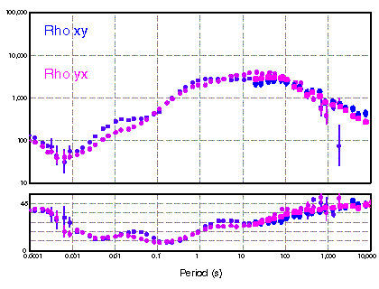
Figure 2 illustrates an example of the V5 and LIMS data from a site just to the west of Rae on the Great Bear magmatic arc (Site 101). Even at this level of processing of the LIMS data, the overall data quality from both systems can only be described as superb. Believable V5 data were even acquired in the AMT "dead-band" of 1-3 kHz, albeit with lower quality. The absence of anthropogenic noise and low electric field distortion compound to give highly precise estimates of the magnetotelluric impedance tensor in all elements for almost all sites, which is rarely the case for MT data acquired on highly resistive regions (cratons, batholiths, etc.).
Results
Preliminary analyses and interpretation of the MT data have been conducted, and indicate features that are important for the Slave craton specifically, and possibly for the geological history of the early Earth in general.
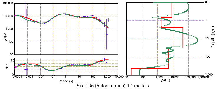
The Anton terrane shows no conducting lower crust (Figs. 3 and 4). This is in contrast to all other Archean cratons, such as the Superior, Kaapvaal, and Siberian, and younger-aged (Proterozoic and Phanerozoic) crusts. Although the cause of lower crustal conductivity is controversial, with either interconnected saline fluid or interconnected grain-boundary carbon being the two most currently-promoted theories, the absence of either of these beneath a terrane hosting the oldest dated rocks on Earth is a first-order result.
Beneath the Anton terrane there is an order of magnitude increase in conductivity at a depth corresponding to the crust-mantle boundary (Fig. 4). This observation, of the electrical equivalent of the seismic "Moho", is a first, as at other locations the existence of a lower crustal conductor precludes confirmation of a crust-mantle conductivity contrast.
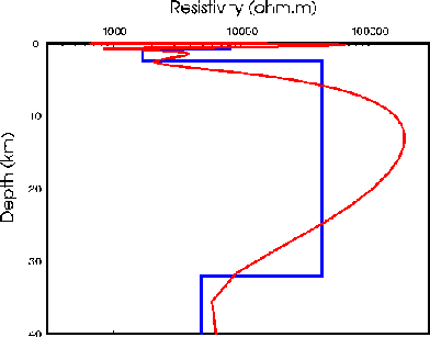
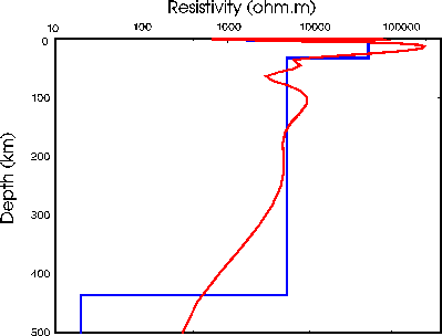
The lithosphere beneath the Anton terrane is laterally homogeneous, thicker and more resistive compared to lithosphere to both the east and west. Models show that it is resistive (>1,000
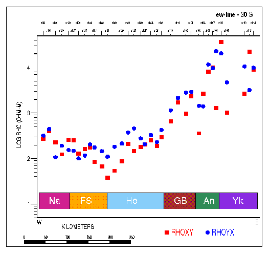
W.m) to at least 250+ km depth (Fig. 5).The lateral variation in the subcrustal lithosphere can be derived from the lateral variation in the MT parameters. Figure 6 shows the apparent resistivities at a period that is sampling about 50 km into the lithosphere (30 s). The values rise from 100-300
W.m on the Proterozoic terranes to around 10,000 W.m on the Slave craton. This rise occurs mostly on the Fort Providence - Rae section of the Profile (GBMZ). These results imply that the lithosphere thins dramatically westward beneath the Great Bear magmatic zone, from 250+ km to 100+ km.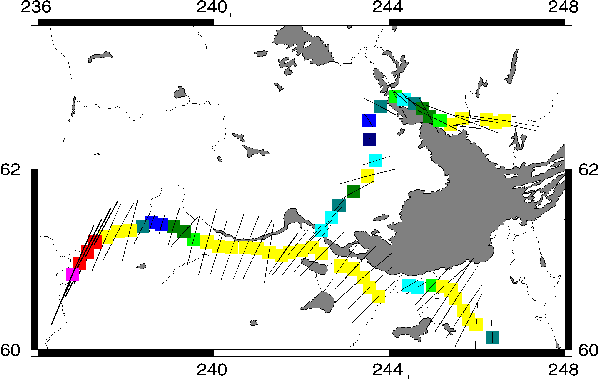
By studying the phase difference between orthogonal impedances of the MT tensor, it is possible to determine whether there is any anisotropy in the measurements associated with structures, similar to the SKS technique in seismology. Figure 7 displays the phase differences for all stations at a period which samples around 50 km depth in the subcrustal lithosphere (30 s). Beneath stations around Yellowknife, the lithosphere is electrically anisotropic, with the more conductive direction being around N105E (Fig. 6), compared to the seismic SKS direction for RSNT of N48E. The lithosphere is laterally homogeneous between Fort Providence and Rae, but becomes anisotropic west of Fort Providence (Fig. 7).
Sites around the Great Slave Lake shear zone display a strong anisotropy with a most conductive direction of N35E (Fig. 7), i.e., oblique to the direction of the GSLsz of N45E. This obliquity is consistent with the dextral movement sense on the shear zone (hypothesis of Ji et al., 1996), and suggests that the GSLsz penetrates deep into the mantle.
These results already speak directly to various of the defined transect objectives. Those on the Anton terrane give support for the contention of Padgham and Fyson (1992) that at least part of the Slave exhibits distinctive features not apparent in the Superior or other Archean cratons.
In addition, very long period MT recording is being made within the Yellowknife seismic array (at seismic station B4). The LIMS system deployed there has been modified to remove the high-pass 30,000 s analogue filters on the telluric channels. It is intended to remain in place for at least two years in order to try to obtain a long record from which very long period MT responses can be derived. The success of the work in Carty Lake on the Superior craton (Schultz et al., 1993), where a conductivity-depth curve was defined to depths in excess of 1,000 km exhibiting discrete conductivity jumps near depths of 425 km and 660 km, motivated this deployment.
Future MT measurements
Vehicle access of the Slave craton is very limited, and Echo Bay's winter road provides a logistical opportunity to extend the geophysical observations from around the southwest corner of the Slave to well into the interior. In particular, the winter road affords the possibility to cross the Sleepy Dragon Complex and the Contwoyto Terrane, and to map electrically the lateral variation of the crust and sub-crustal lithosphere across the Slave craton.
MT along the winter road is an affordable geophysical method for obtaining information on the regional-scale lateral variation of the Slave's lithosphere, and will contribute significantly to the objectives of the transect. The winter road has a total length extent of 600 km, and requires a minimum of 40 MT sites along it to characterize the substructure electrically. The results should provide an improved picture of the assembly of the Slave Province and allow evaluation of models such as that of Helmstaedt and Schulze (1989) and Kusky (1989) etc.
Questions to be addressed are:
Measurements along the winter road are planned for February-April, 1998. This work is partially supported by contributions from industry.
Auxiliary "Slave Lakes" Experiment
A proposal will be resubmitted to the National Science Foundation for an experiment in which ocean-bottom instrumentation will be placed in lakes around the southern and central Slave. The instruments belong to Dr. Alan Chave at Woods Hole Oceanographic Institution. If this experiment is funded, we will install the systems in mid-July, 1998, with a recording rate of 1 s. They will be retrieved in mid-September, 1998, and redeployed with a slower recording rate (60 s) for ten months. This should give us a year of data from each of the nine lakes, which will give information on the large scale lateral variability of conductivity to depths in excess of 400 km to compare with the Superior Province (Schultz et al., 1993).
References
Berry, M.J. and J.A. Mair, 1977. The nature of the Earth's crust, in Canada AGU Geophys. Mon. 20, J.G. Heacock, Editor, Washington, D.C., 319-348.
Helmstaedt, H.H., and D.J. Schulze, 1989. Southern African kimberlites and their mantle sample: implications for Archean tectonics and lithosphere evolution, in J. Ross (ed.), Kimberlites and related rocks, vol. 1: Their composition, occurrence, origin, and emplacement, Geol. Soc. Aust. Spec. Pub., 14, 358-368.
Ji, S., S. Rondenay, M. Mareschal and G. Senechal, 1996. Obliquity between seismic and electrical anisotropies as a potential indicator of movement sense for ductile mantle shear zones. Geology, 24, 1033-1036.
Kusky, T.M., 1989. Accretion of the Archean Slave province. Geology, 17, 63-67.
Owens, T.J., S.R. Taylor and G. Zandt, 1987. Crustal structure at regional seismic test network stations determined from inversion of boradband teleseismic P waveforms. Bull Seism. Soc. Am., 77, 631-662.
Padgham, W.A. and W.K. Fyson, 1992. The Slave Province: a distinct Archean craton. Can. J. Earth Sci., 29, 2072-2086.
Schultz, A., R.D. Kurtz, A.D. Chave and A.G. Jones, 1993. Conductivity discontinuities in the upper mantle beneath a stable craton. Geophys. Res. Lett., 20, 2941-2944.