Page 1
 
E-mail Phoenix Phoenix Home
 
D I A M O N D S   A N D   I C E
 
Phoenix crew members Lucien Patry, Doris LaBrecque and Gary McNeice install V5 System 2000 MTand Long Period MT equipment in an insulated box on lake ice in Canada's Northwest Territories. Snowmobiles were used to access the sites which were several km off the winter road. Manmade noise Is absent here but a strange new noise source turned out to be the Northern Lights (aurora).
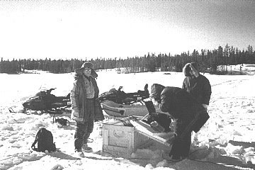
A winter "ice road" stretches 600 km north of Yellowknife in Canada's Arctic, mainly across frozen lakes. During the frigid northern winter, the ice road is used to truck supplies to the new diamond mines in the Lac de Gras region. (In the summer there are no roads at all.) Using nature's road, Phoenix conducted an innovative combined Long Period MT/MT survey in March of 1998, for the Geological Survey of Canada (GSC) and Lithoprobe, to determine the thickness of the Earth's lithosphere near the diamond mines. Diamonds are formed 150 km deep in the earth, where the rock is molten and enormous pressure squeezes carbon atoms into a tetrahedral crystal form. Diamonds get to the surface when zones of weakness develop in the depths and the molten rock, carrying diamonds, begins its ascent to the surface. Forcing its way upward faster than a race horse can run, the molten rock bursts through the surface and then cools.The lava eventually weathers to a type of rock first found near Kimberley, South Africa. Ever since these diamond-bearing, carrot-shaped bodies have been called "kimberlite pipes". In the last few years, kimberlites have been discovered in northern Canada; some of the pipes contain diamonds in commercial quantities. Whether or not a pipe contains commercial diamonds depends on how deep the lava originated. It must come from at least 150 km deep where the pressure is high enough to create commercial grade diamonds. The earth's lithosphere is 150 km or more thick only in the centres or "keels" ofthe ancient continents, areas which have been land for hundreds of millions of years. These ancient continental cores are called "cratons"; and it is only in era-tons that kimberlite pipes will produce commercial diamonds. To know whether a kimberlite contains commercial quantities of diamonds or not, diamond companies must mine and process several tens of tons of rock. This is obviously very costly. If you could "just" measure the thickness of the lithosphere, you would know whether to expect diamonds or not.
But how? There is no man-made signal strong enough to investigate these depths. One way is to use the so-called "teleseismic" technique, observing the seismic waves from distant earthquakes and deducing the depth of the solid-liquid boundary from the change in character of the waves. But this is tedious, expensive and imprecise.
Another way is to use Long Period Magnetolellurics. MT senses conductivity contrasts; there is a significant and measurable contrast at the solid-liquid boundary at the bottom of the crust. Dr. Alan Jones of the GSC developed the concept of using long-period MT in this way in the article "Geophysical measurements for lithospheric parameters" published in Searching for Diamonds in Canada. The interpretation of the long-period (LRMT) measurements is improved by having additional, higher-frequency information the MT band.
The hard part is how to actually carry out a combined Long Period MT/MT survey in the Arctic craton of Canada with a limited budget. A helicopter-supported summer survey is too costly. A winter survey along the ice road costs less but is technically challenging because of the low temperatures (as low as -33°C), the difficulty of making electrode contact on the ice, of making magnetic measurements on the moving lake ice and of logistics in general, especially weight of equipment and batteries.
Power consumption is a key issue because for every 20"C drop below +20°C, battery capacity drops by half. Low-powered equipment is a must so this dictated the use of the V5 System 2000 for the MT measurements, since each System 2000 MTU box weighs only 4kg, and uses only 8 watts, with a battery of only 8kg. Besides, since the telluric measurements had to be made on and through the lake ice, a system with separated telluric/magnetic measuring capability - the System 2000 - was essential.
For the long-period measurements, the GSC's "LiMS" (Long Period Magnetotelluric System) units were used. To conserve heat, the systems were installed with batteries in special insulated equipment boxes. Telluric measurements were made on the lake ice and magnetic measurements nearby on the "portages" where the ice road crosses islands.
Phoenix crew members Lucien Patry, Doris Labrecque and Gary McNeice worked with James Cassels and Alan lones of the GSC. In just 21 days, the crew mobilized, tested sites near Yellowknife, drove hundreds of km up the winter road, installed and acquired 11 combined LRMT/MT sites, drove up to 200 kilometres a day dodging heavy trucks and blowing snow, trekked by snowmobile to off-road sites and finally demobilized - all without any significant equipment problems. Congratulations to the expert crew on a job well done under extremely difficult conditions!
Thanks also to the very helpful people of the Northwest Territories, who generously provided valuable assistance and advice during the survey.