Regional electrical structure of the Trans-Hudson Orogen
| Alan G. Jones | Geological Survey of Canada, 1 Observatory Crescent, Ottawa, Ontario, K1A 0Y3 |
| Xavier Garcia | Universitat de Barcelona, Dep. de Geologia Dinamica,
Zona Universitaria de Pedralbes, 08028 Barcelona, Spain. Also at Geological Survey of Canada, 1 Observatory Crescent, Ottawa, Ontario, K1A 0Y3 |
| Nicholas J. Grant | Gaia Geoscience, P.O. Box 4175, Station "E", Ottawa, Ontario, K1S 5B2 |
| Juanjo Ledo | Universitat de Barcelona, Dep. de Geologia Dinamica,
Zona Universitaria de Pedralbes, 08028 Barcelona, Spain. Also at Geological Survey of Canada, 1 Observatory Crescent, Ottawa, Ontario, K1A 0Y3 |
| Ian J. Ferguson | Department of Geological Sciences, University of Manitoba, Winnipeg, Manitoba, R3T 2N2 |
Abstract
The Paleoproterozoic Trans-Hudson Orogen (THO) extends from southern South Dakota north through North Dakota and Saskatchewan, then swings eastward through northern Manitoba into Hudson Bay. Beyond that, it is believed to extend into Greenland, and perhaps has a counterpart in Scandinavia. A geophysical signature of the THO is the North American Central Plains (NACP) conductivity anomaly.
Magnetotelluric studies along five profiles in Saskatchewan map the NACP from south to north. In a gross sense, the NACP can be identified with tectonic elements in the western part of the orogen, and where exposed has been shown to be due to sulphides within the western La Ronge belt. However, in detail the anomaly shows considerable variation in the internal structure. Part of this may be due to the blanketing effect of the conducting Paleozoic sedimentary fill of the Williston Basin, but part of it cannot be explained in that way.
Geoelectric strike directions are fully consistent with the speculated geometry of the THO, with north-pointing strikes in southernmost Saskatchewan rotating to -20O, then +20O then +60O going to northernmost Saskatchewan.
The derived conductivity models are consistent with conductivity anisotropy below the scale of the sensing electromagnetic fields. The variations in the internal structure need further study. A new result from these modelling studies is the identification of conductivity anomalies in the deep crust lying beneath the arcuate mid-crustal structures previously detected. These anomalies have the same strike as the shallower ones, suggesting that the presumed Sask craton is not of whole crustal extent.
I INTRODUCTION
Over the decade 1984-1994, a total of 200+ magnetotelluric sites were occupied in Saskatchewan to study the enigmatic North American Central Plains (NACP) conductivity anomaly. This anomaly in enhanced electrical conductivity was first detected in the late 1960s, and has been the cause of much study and speculation since. It has since been unequivocally associated with the Paleoproterozoic Trans-Hudson Orogen (THO), and, in fact, was the first geophysical evidence for the continental extent of the orogen (Camfield and Gough, 1977).
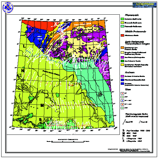
The MT sites lie along five lines in Saskatchewan, which are labelled (from south to north), lines S, M, N, L, and X (Fig. 1).
Date for east-west line S data were acquired for Pan-Canadian Oil Co. Ltd. in 1984 and 1985, by Phoenix Geophysics. The frequency range covered was 384 Hz - 1820 s. They have been presented and discussed in Jones and Savage (1986), Jones (1988a, b), Jones and Craven (1990), and have been interpreted by ten others in a comparison of modelling and inversion approaches (see Jones, 1993, and references therein).
East-west lines M and N data were acquired by the GSC in 1987 using Phoenix equipment. The frequency range covered was 384 Hz - 1820 s. The data have not previously been modelled, but the responses were displayed and qualitatively interpreted in Jones and Craven (1990).
East-west line L and north-south line X data were acquired for Lithoprobe by a commercial contractor, Phoenix Geophysics, in 1992 and 1994 respectively. The frequency range covered for both surveys was 10,000 Hz - 1820 s. In addition, long period measurements were made at most sites along line X, increasing the period (and accordingly depth penetration), to >3,000 s. The data from the western part of line L were analysed and modelled in Jones et al. (1993). The line X data have been processed in Garcia et al. (1997) to remove source-field contamination.
This paper gives an overview of the regional results, showing the geoelectric strike information and the 2D conductivity models derived to explain the observations.
II GEOELECTRIC STRIKE DIRECTIONS
If the regional structures are predominantly two-dimensional, then the 2x2 magnetotelluric impedance tensor assumes a simple anti-diagonal form when aligned parallel and perpendicular to strike. One of the terms of the tensor represents the response for currents flowing along the structure (the TE, for transverse-electric, mode of induction), whereas the other term represents the response for currents flowing across the structure (the TM, for transverse-magnetic, mode of induction). This simple form is unfortunately often masked by local, near-surface distorting bodies. However, using a tensor decomposition approach advocated by Groom and Bailey (1989), and extended by McNeice and Jones (1996), it is possible to detect, analyse and remove these distorting effects and derive both the regional strike direction and the regional TE and TM impedances. The distortion analyses for all the data from line L are discussed in detail in the accompanying paper by Jones and Grant (1997), to which the reader is referred for more information about the methodology of distortion removal.
Geoelectric strike directions derived are shown on the map for each site for the period band 10 - 1000 s (Fig. 1). At these periods. the natural source electromagnetic fields penetrate deep into the crust and underlying uppermost mantle on lines L and X. The penetration is somewhat less at these periods on lines M, N and S because the overlying conductive sediments absorb and attenuate the electromagnetic waves. These arrows thus depict the geoelectric strike direction for the bulk of the crust.
The strike directions determined are plotted on the geology map. The direction of each arrow denotes the strike direction for that site. The length of the arrow denotes how well the data are fit by the distortion model. Long arrows indicate an excellent fit of the distortion model to the data. Short arrows indicate a poor fit - this is either due to overly optimistic error estimates, or to 3D inductive effects due to complex 3D geometry of conductive structures.
Note for line S that the arrows are pointing virtually due north. For line M, they indicate a strike direction of -20O (N20W). For line N they are +20O (N20E). For line L the data suggest two sets. The eastern half of the line (LE) indicates a strike of +20O, and the western half (LW) a strike of +30O (Jones and Grant, 1997). Line X generally indicates a strike of +60O.
This locationally-dependent strike is consistent with the presumed geometry of the THO, and with features in the potential field maps (not shown).
III DATA DISPLAYS
The regional impedances have both a magnitude (apparent resistivity) and a phase for each of the two models of induction (TE and TM) at each frequency. The magnitudes and phases are not independent of each other, but in fact form a Hilbert transform pair - that is from one of them one can derive an estimate of the other (to within the constant of integration). However, the apparent resistivities can be plagued by static shifts, which are the remaining effect of local distortion that need to be removed by referring to other information (see, e.g., Jones, 1988). Accordingly, as the phase plots contain the same information as apparent resistivity plots, but are not affected by static shifts, they are more commonly used for qualitative interpretation.
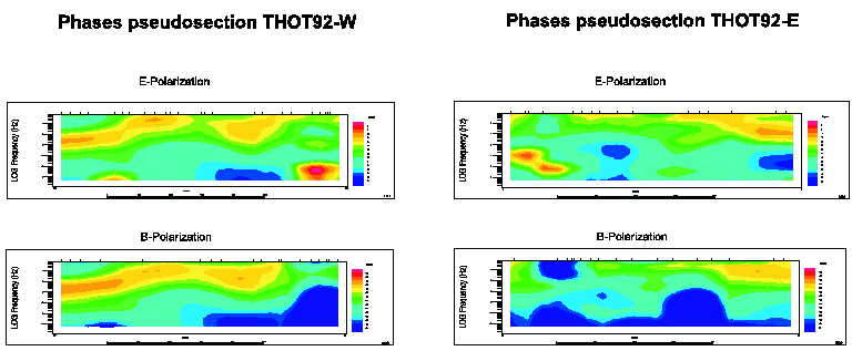
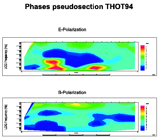
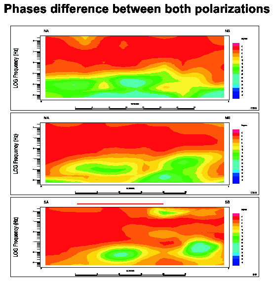
We display two types of contoured phase displays. The ordinate for both is log(period), which is a proxy for depth as electromagnetic fields attenuate exponentially with increasing penetration. For the northern two lines, L and X, we show the TE and TM phases as contoured plots (Fig. 3a for line L and Fig. 3b for line X ). For the southern three profiles however, we display the phase differences between TE and TM (Fig. 2). This is because on these profiles there is virtually no observable TM response due to the crustal conductivity anomalies, only a TE response. This lack of TM response is taken as evidence for many bodies rather than a single composite anomalous body, and is discussed in detail for the S line data in Jones (1993). Accordingly, a way of illuminating the anomalies and separating the background response is to plot the
fTE - (fTM + 180O) (the 180O accounts for the TM phase being in the third quadrant) as contoured phase plots. For a 1D rotationally invariant Earth this phase difference will be zero. Departures from zero imply 2D or 3D structures.III.1 Phase Difference Plots: Lines S, M and N
Phase difference contoured plots for lines S, M and N are shown in Fig. 2 (bottom, middle and top respectively). The phase difference between both polarizations for short periods is less than 3O due to the 1D electrical structure of the Phanerozoic sediments. These sediments shallow to the north and east. For long periods (>10 s), the phase differences between both polarizations are greater (>15O) due to the 2D crustal electrical structure.
The S profile shows, for periods longer than 100 s, two zones where the phase differences are >24O. The westernmost anomaly is associated with the NACP conductivity anomaly, and the easternmost one with the TOBE anomaly (Jones and Craven, 1990).
The M profile also shows two zones of enhanced difference between phases at longer periods, although they are weaker than on the line S data. The western anomaly is associated with the NACP, and the eastern anomaly is due to a body close to the basement surface.
The N profile differs from the previous two in showing an anomaly in the extreme western part of the profile where the phase difference is >20O. This suggests the existence of an anisotropic structure.
III.2 Phase Plots: Lines L and X
Phase data from each station have been interpolated along each line to produce 2D phase contoured plots for both the TE and TM modes (Figs. 3). Phases above 45O indicate zones of enhanced conductivity with depth.
IV MODELLING AND INVERSION
The models to explain the observations were derived using two different philosophies. For the three lines on Phanerozoic sediment, lines S, M and N, a forward trial-and-error model fitting approach was used. For the other two lines, lines L (split into LE and LW), and X, an automatic inversion code was used. Whereas inversion schemes have the attraction of employing objective misfit and regularization criteria, there is a danger of not fitting subtle, significant features when a global misfit is sought. In comparison, detailed forward modelling exercises can be accomplished with due care being given to parts of the responses that are sensitive to the features of interest. This is possibly the case for the N line dataset, as the objective algorithm will penalise attempts to introduce anisotropic structure (see below).
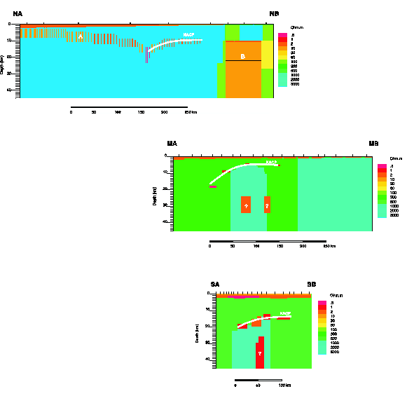
All the models shown in Figs. 4-8 are coloured with the same grey scale for resistivity for ease of comparison.
IV.1 2D Forward Models: Lines S, M & N
Forward models for lines S, M and N were produced from repeated attempts to fit the data obtained from a 2D model to the measured data for each station -- the forward trial and error fitting method. The model data were calculated using the code of Wannamaker et al. as part of the Geotools data interpretation package. Parts of the starting models for this process were produced from RRI inversions, but all subsequent models were modified "by hand" to fit observed features in the data. The models are shown in Figs. 4, 5 and 6.
IV.1.1 Sedimentary structure
The three models all show a conductive surface layer which is the Phanerozoic sediments. The thickness of the layers beneath each site has been taken from isopach maps of the depth to basement.
IV.1.2 Crustal structure
The crust is, in general, resistive (
r>600 W.m). In models for the S (Fig. 4) and M (Fig. 5) profiles, conductive structures at depths greater than 20 km are present. In the eastern zone of model N (Fig. 6), a conductive body is present; this body can be related to the structures in the model THOT92-East (see below). The geological interpretation of this body is unclear.IV.1.3 NACP structure
The three models all show a series of west-dipping conductive bodies in the middle crust associated with the NACP. The top of the structure is shallower in model M., and the amount of conducting material (conductance, or depth-integrated conductivity) is less. To fit the data, the NACP must be modelled as a series of conductive bodies rather than a single feature (multi-body structure, Jones and Craven, 1990). The separation of the MT sites and the depth of the NACP prevent us from knowing whether the NACP is a macro-anisotropic structure, or a micro-anisotropic one (Jones et al., 1997). In addition, beneath the N-line, the anisotropic structure extends to the western end of the line well into the presumed Wollaston Domain, as expressed by the phase structure in Fig. 2c.
IV.2 2D RRI Models: Lines LE, LW & X
Models for lines X, LW and LE were obtained using the RRI (Rapid Relaxation Inversion) of Smith and Booker (1991). The RRI program seeks the smoothest conductivity profile such that the value of a functional which includes the derivatives of the conductivity with respect to depth and in the horizontal direction along the profile, is minimized simultaneously with misfit. Beginning with the responses obtained from a 2D start model, RRI repeatedly solves for small changes in the conductivity profile at each site such that the new conductivity produces a smaller residual error between the modelled data and measured data at each station.
IV.2.1 THO92 East (Profile LE)
Well resolved conductors are present in this model towards the western extreme of the profile (Fig. 7a). A shallow conductor is located at a depth of ten kilometres but extends to a depth of one or two kilometres. A second conductor has been resolved by the RRI program under the first at a depth of near 20 km, but the position of this conductor and its vertical extent must be viewed with a great deal of scepticism, as the EM waves carrying information about the conductivity structure at this depth will have been attenuated by the shallow conductor. A highly resistive shelf extends over a deeper, more conductive zone at a depth of 30 km-- a zone possibly associated with the Thompson Belt (TOBE) conductive anomaly.
IV.2.2 THO92 West (Profile LW)
The features of this regional model (Fig. 7b) largely confirm the findings of Jones et al. (1993). A large resistive structure situated at a depth of near 5 km overlies a conductor located at a depth between 10 and 15 km; we associate this resistive structure with the Wathaman Batholith. A conductor is linked via a westward dipping conductive zone to a second conductor, and we associate both with the North American Central Plains Anomaly.
Question marks indicate regions where the RRI model is highly uncertain:
1 Conductors are found at a depth of 25 km, but it is not known with what geological features these may be associated. The vertical extent of such a conductor as mapped by an RRI inversion is dubious at best.
2 Poor or unfittable data from several stations near the eastern end of the profile were omitted and therefore the shallow structure under the gap between stations is result of the inversion and subsequent interpolation of higher frequency data from the stations at either end of the gap. Information about structure at depth has been lost as well-- though sites on either side of the gap in the profile "see" essentially the same structures at the longest periods.
IV.2.3 THOT94 (Profile X)
This regional model (Fig. 8) shows two main zones associated with different behaviour of the electrical response. The northernmost part can be associated with the Wollaston Fold Belt in the Hearne Craton extending until the Peter Lake Domain in the Reindeer zone, and the Southern one associated to La Ronge Domain, also in the Reindeer zone.
The northern part of the model shows a massive, highly resistive body extending from the Wollaston Fold Belt to the Peter Lake Domain. This body dips to the South and appears to be split in two by a conductive horizontal structure, reaching a maximum depth of 30 km. The conductor is present in the phase pseudosections as a high phase zone around 1 s. These bodies cannot be modelled properly with the inversion program as they display non two-dimensional behaviour when fitted to a Groom-Bailey distortion model. However, the presence of these conductors can be inferred from inductive effects observed in the data at the neighbouring sites. The strong conductor that appears at a depth of 40 km under the resistive body seems to be an artifact of the RRI inversion program which permits the response of the model to be conductive at long periods.
V CONCLUSIONS
V.1 NACP
The NACP zone of enhanced conductivity has been imaged electrically from the U.S./Canadian border to northern Saskatchewan on five crossing profiles. Although in a gross sense the anomaly appears to be the same on all lines, in detail it displays an internal structure that varies along strike. Its absence along line M was suggested by Jones and Craven (1990) in their qualitative interpretation of the data. However, distortion analysis showed that the correct interpretation frame should be -20O, not 0O as used by Jones and Craven (1990). This difference is insignificant for the larger impedance, which is the TM impedance, but is highly significant for the smaller impedance, the TE impedance, which is precisely the one that is sensitive to the presence of the anomaly. This confirms that care must be taken when determining the appropriate interpretation coordinate system for MT data.
V.2 Deep Crustal Conductor
All models, except for line N, display distinct, and mostly separate, bodies of enhanced conductivity deep in the crust, from 25 - 35 km, beneath the overlying arcuate mid-crustal anomalies previously imaged. The nature of this deep anomaly is unknown. Note that following the interpretation of the seismic reflection data by Lucas et al. (1993) and Nelson et al. (1993), they lie within the Archean craton (Sask craton) that is interpreted to root the orogen. This suggests that either (1) the presumed metasediments are Archean in age, or (2) the Archean remnants are thin and underlain by younger (Paleoproterozoic?) rocks containing metasedimentary sequences. As the strikes of these deep crustal bodies are in exactly the same direction as the upper crustal ones, we suggest that the latter explanation is more likely.
V.3 Anisotropic Crust
The upper crust in the western Hearne craton beneath line N appears to be electrically anisotropic. Whether this is also true beneath the western part of line LW needs to be tested, as the smooth inversion algorithm will not produce such a feature.
References
Camfield, P.A. and D.I. Gough, 1977. A possible Proterozoic plate boundary in North America. Canadian Journal of Earth Sciences, 14, 1229-1238.
Garcia, X., A.D. Chave and A.G. Jones, 1997. Robust processing of magnetotelluric data from the auroral zone. Journal of Geomagnetism and Geoelectricity, in press.
Groom, R.W. and Bailey, R.C., 1989. Decomposition of magnetotelluric impedance tensors in the presence of local three-dimensional galvanic distortion. Journal of Geophysical Research, 94, 1913-1925.
Jones, A.G., 1988a. Static shift of magnetotelluric data and its removal in a sedimentary basin environment. Geophysics, 53, 967-978.
Jones, A.G., 1988. Discussion of "A magnetotelluric investigation under the Williston Basin'" by J.M. Maidens and K.V. Paulson. Canadian Journal of Earth Sciences, 25, 1132-1139.
Jones, A.G., 1993. The COPROD2 dataset: Tectonic setting, recorded MT data and comparison of models. Journal of Geomagnetism and Geoelectricity, 45, 933-955.
Jones, A.G. and J.A. Craven, 1990. The North American Central Plains conductivity anomaly and its correlation with gravity, magnetic, seismic, and heat flow data in Saskatchewan, Canada. Physics of the Earth and Planetary Interiors, 60, 169-194.
Jones, A.G., J. A. Craven, G. W. McNeice, I. J. Ferguson, T. Boyce, C. Farquhason, and R. G. Ellis, 1993. North American Central Plains conductivity anomaly within the Trans-Hudson orogen in northern Saskatchewan, Canada. Geology. 21, 1027-1030.
Jones, A.G. and N.J. Grant, 1997. Geoelectric strike directions for the 1992 THOT MT data. THOT Transect Report.
Jones, A.G., Katsube, T.J. and Schwann, P. 1997. The longest conductivity anomaly in the world explained: sulphides in fold hinges causing very high electrical anisotropy. Journal of Geomagnetism and Geoelectricity, submitted.
Jones, A.G. and P.J. Savage, 1986. North American Central Plains conductivity anomaly goes east. Geophysical Research Letters, 13, 685-688.
McNeice, G. and A.G. Jones, 1996. Multisite, multifrequency tensor decomposition of magnetotelluric data. Contributed paper at the 66th Annual Society of Exploration Geophysics meeting, held in Denver, Colorado, on 10-15 November. Expanded Abstracts, 66, 281-284.
Smith, J.T. and Booker, J.R., 1991. Rapid inversion of two and three-dimensional magnetotelluric data. Journal of Geophysical Research, 96, 3905-3922.
Wheeler, J.O., P.E. Hoffman, K.D. Card, A. Davidson, B.V. Sanford, A.V. Okulitch and W.R. Roest (comp.), 1997. Geological map of Canada. Geological Survey of Canada, Map D1860A.
Figure Captions
Figure 1
Predominant geoelectric strike directions for the crust and uppermost mantle for Saskatchewan and western Manotiba on a geology map of the region (taken from Wheeler et al., 1997). The direction of each arrow denotes the best strike direction for the period band 10 - 1,000 s, and the length denotes how well the decomposition model fits the data. Long arrows denote an acceptable fit, whereas short arrows denote a poor fit, due to either unrealistically small error estimates or to three-dimensional structures.
Figure 2
Phase difference contoured plots for lines S (2a), M (2b) and N (2c).
Hot colours denote little phase difference, and infer a 1D rotationally-invariant Earth, whereas cold colours to white denote a large phase difference, indicative of 2D (or 3D) structure.
Figure 3
a) TE and TM phases for lines LE and LW
b) TE and TM phases for line X
Cold colours denote low phase, and are indicative of resistive regions.
Hot colours denote high phase, and are indicative of conductive regions.
Figure 4
2D forward model for line S
Figure 5
2D forward model for line M
Figure 6
2D forward model for line N
Figure 7
a) 2D inverse model for line LE
b) 2D inverse model for line LW
Figure 8
2D inverse model for line X