LITHOPROBE Slave-Northern Cordillera Lithosphere Evolution (SNORCLE) Transect
Winter Road Data Acquisition

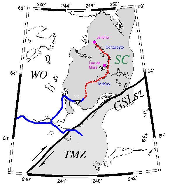
The winter road (red dashed line)
runs 600 km from the eastern end of the Ingraham Trail to
Echo Bay's Lupin Mine on COntwoyto Lake.
The road provides access to BHP's diamond mine and DiaMet's property at
Lac de Gras.
There is a 20 km extension to the Jericho kimberlite pipe being studied by
Canamera Geological and Lytton Minerals.
The Lupin Mine was closed in January, 1996, and accordingly access beyond
Lac de Gras is limited.
EM leader.....
Collaborators.....
Financial Sponsors.....
- Geological Survey of Canada
- Natural Sciences and Engineering Research Council of Canada (Lithoprobe)
- Indian and Northern Affairs Canada
- Monopros
- Kennecott
- B.H.P.
Project Overview.....
Vehicle access of the Slave craton is very limited, and Echo Bay's winter
road, which runs from Tibbit Lake (east end of Ingraham Trail) to the Lupin
gold mine on Contwoyto Lake, provides a logistical opportunity to extend
the geophysical observations from around the southwest corner of the Slave
to well into the interior. In particular, the winter road affords
the possibility to cross the Sleepy Dragon Complex and the Contwoyto
Terrane, and to map electrically the lateral variation of the crust and
sub�crustal lithosphere across the Slave craton.
MT along the winter road
is an affordable geophysical method for obtaining information on the
regional�scale lateral variation of the Slave's lithosphere, and will
contribute significantly to the objectives of the SNORCLE transect.
The winter road has a total length extent of 600 km, and with a station
spacing about 1.5 times that on the Yellowknife to Rae portion of the
transect, which was 10 km, would require a total of 40 MT sites along it
to characterize the substructure electrically. The results should provide
an improved picture of the assembly of the Slave Province and allow
evaluation of models such as that of Helmstaedt and Schulze (1989) and Kusky (1989) etc.
Obvious questions to be addressed are:
-
Is the lack of a lower crustal conductor a Slave characteristic, or just
an Anton terrane one? Or is it associated with the older rocks (>2.8 Ga)
thought to underlie much of the west compared to the east?
-
Is there a difference between the mantle lithospheres on either side of the
Pb isotope boundary?
-
Is the lithosphere in the northern part different from the south as a
result of modification caused by the emplacement of the plume that generated
the MacKenzie dyke swarm (1280 Ma)?
-
What is the crustal geometry of the Sleepy Dragon complex
EM Activities.....
Pilot phase undertaken in March-April, 1998

Press for full-sized map (178 Kb)
|
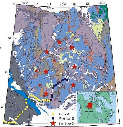
Acquisition at a total of eleven (11) sites from Tibbit Lake to MacKay Lake,
with three of these at the southern end of the line, and the other eight
on an east-west profile from northern Gordon Lake to MacKay Lake.
Site locations shown on map as black squares.
Other sites are from the
SNORCLE 1996 MT data acquisition (yellow circles)
and the
1998 Slave Lakes experiment (red
stars)
|
Published Reports and Papers.....
Presentations.....
Links...
 MTNet Home Page
 Alan's Home Page
Alan G Jones / 22 April 2006 /
 alan-at-cp.dias.ie


 MTNet Home Page
 alan-at-cp.dias.ie